
Surveying for your construction site in Mecklenburg-Vorpommern
Construction surveying: setting out, site support, monitoring
Axes on the batter boards, heights for the foundation base, checks on the neighbouring buildings: we survey alongside construction, in step with your schedule. We document every measurement so that site management and client can work with it.
No obligation · quote in advance
- Building construction and civil engineering
- Setting out to the millimetre
- Monitoring also permanently with alarm

What does your construction site need?
Four tasks that site managers and clients bring to us.
-
The axes must go on the batter boards
Site control network, rough and precise setting out, height reference points: so that what is approved and planned is built.
-
The excavation is deep, and there is an old building next door
Detect settlement, tilt and deformation of neighbouring buildings, excavation walls or tracks before damage occurs.
-
How much soil has really been moved?
Surveys before and after excavation, plus terrain models for planning and billing.
-
Has it been built as planned?
Check survey of the construction work, longitudinal and cross sections, reliably documented.
Setting out and site control network
So that what is planned gets built
Every setting out is based on a site control network for position and height. These are fixed points that we determine precisely once. All further measurements during construction refer to them. On this basis we set out what your construction schedule needs at the time.
Rough setting out marks the main points, the site, the excavation and the outdoor areas for the earthworks. Precise setting out fixes axes and points to within a few millimetres, with nails on wooden pegs or on the batter boards (Schnurgerüst). We document every setting out in a setting-out plan (Absteckungsplan) and hand it to site management and client.
Are you building your own house? What your task is as the client is explained on the page Surveying for your new house.
- Set up and monitor the site control network for position and height
- Rough setting out for earthworks and excavation
- Precise setting out of axes and points, on pegs or batter boards
- Height reference points for construction
Do you need setting out?
Request setting out
Deformation and settlement measurement, monitoring of structures
Monitoring settlement and movement
Deep excavations, lowering of groundwater and vibrations have effects beyond the construction site. Before construction starts, we determine measuring points on neighbouring buildings, excavation walls or tracks in a zero measurement (Nullmessung). During construction we measure again at fixed intervals and show whether and how far something moves.
Where a fast reaction is needed, we monitor permanently. Sensors record movements down to fractions of a millimetre and send their values to a platform. If an alarm value is exceeded, messages go automatically by email or text message to the people responsible.
Recording the condition before construction starts is also worthwhile legally. More on this under expert reports and evidence.
- Zero measurement before construction starts, follow-up measurements during construction
- Neighbouring buildings, excavation walls, tracks and ground
- Permanent monitoring with alarm values where needed
- Measurement reports compared with the initial condition
Do you need to monitor movements?
Request monitoring
From practice: new Volkstheater Rostock
Since March 2025 we have been providing surveying for the new theatre building in the centre of Rostock.
-
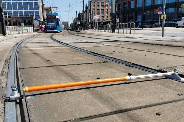
Control network and track monitoring
For the client we set up a control network, the basis of all setting out. On this basis we regularly monitor the surrounding ground, the Haus der Schifffahrt and the tram tracks at Kröpeliner Tor (article in German).
-
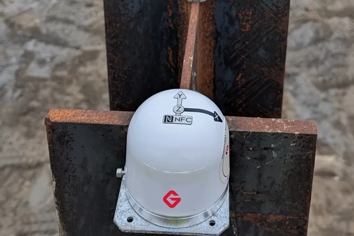
Tilt monitoring of the diaphragm wall
Since January 2026, six tilt sensors have monitored the excavation wall permanently. If an alarm value is exceeded, a notification is sent automatically (article in German).
Ground, volumes and checks
What else is measured on the construction site.
-
Digital terrain models
Where single heights are not enough, a terrain model describes the whole ground surface, without plants and buildings. A basis for planning, routes, volumes and relief analyses, on request with contour lines and hillshading.
-
Earthwork volumes
How much soil is moved? From surveys before and after excavation we calculate the volumes. You get a clear basis for billing and additional claims.
-
Check survey of the construction work
Position and height of what was built compared with the plan, longitudinal and cross sections, as-built survey after completion: reliably documented for acceptance, billing and disputes.
How construction surveying works
Agreed once, then in step with your construction site.
-
Clarify the task
Plans, axes, construction schedule: what must be set out or monitored when, and how accurately?
-
Quote
For single visits or as a framework for the whole construction period. The assessment in advance is free.
-
Measure during construction
We come when the site needs us and coordinate with site management and the trades.
-
Document
Setting-out plan, measurement report or volume calculation, in the formats you work with.
Costs
What does construction surveying cost?
Construction surveying is engineering surveying within the meaning of the HOAI, the German fee structure for architects and engineers. There is no fee regulation for it as there is for official surveys. You receive a binding quote before we start.
The price depends on the number and accuracy of the points, how often we come, whether monitoring is one-off or permanent and which documentation you need. For longer construction periods, a framework for the whole project is worthwhile.
Good to know
- Binding quote before we start, free assessment in advance
- Single visits or a framework agreement for the construction period
- Site plan, setting out and official building survey from one source: the fee for the building survey then drops by 10 %
Frequently asked questions
Engineering surveying
What does engineering surveying include?
Engineering surveying supports the planning, construction and operation of buildings and installations, mostly for larger projects in building construction, civil engineering and hydraulic engineering. It includes the site control network for position and height, setting out, surveys of existing conditions, monitoring of structures and surveys of profiles, longitudinal and cross sections. Typical are high accuracy requirements under difficult conditions.
When are settlement and movement measurements useful?
Whenever construction work can cause movement in the ground or in neighbouring structures. For example, excavations next to existing buildings, lowering of groundwater, piling and vibration work, and retaining walls and bridges. We measure at agreed intervals and compare with an initial measurement made before construction starts. The structural engineer and the soil expert set the permitted values and the reporting route. We report any exceedance immediately.
How accurately do you measure on a construction site?
The required accuracy follows from the task and from the permitted tolerances of the structure, in building construction for example from DIN 18202. Where the highest precision is required, we work with precise levelling and our own control networks.
Why record the condition of neighbouring buildings before construction starts?
Before the first dig, we document the condition of neighbouring buildings, roads and installations. We make an initial height measurement and take photos of any existing cracks. If there is a dispute later about settlement or cracks, there is a reliable basis for comparison. This protects clients and construction companies alike against unfounded claims.
Which coordinate system is used on the construction site?
Usually the official position and height reference system, connected via the satellite positioning service or via official control points. For larger projects we also set up a separate site control network for position and height. It lies outside the area affected by the construction work and is checked regularly. Note that distances from official UTM coordinates are slightly distorted compared with reality. We take this into account when setting out.
What is a setting-out plan?
The setting-out plan (Absteckungsplan) documents the setting out: which points and axes were set out, how they are marked on site and which height reference points apply. We check the setting out and hand the plan to the client and the construction company. It is the common basis if questions about position come up later.
What do I get from you in engineering surveying?
We supply the site control network for position and height, the connection to the official control point network, all kinds of setting out, monitoring of structures, deformation and settlement measurements with a report, and surveys of profiles, longitudinal and cross sections.
Digital terrain models
What is a digital terrain model?
A digital terrain model (DGM) describes the ground surface without buildings and without plants. It consists of height points and of break lines such as slopes, ditches and kerbs. From it you can derive contour lines, profiles and earthwork volumes, for example for development plans, route planning and drainage.
Is the freely available terrain data of the state good enough?
For a first assessment and for large areas it is usually enough. For detailed design, drainage or a volume calculation it is usually too coarse. Kerbs, slope edges and ditches disappear in the grid, and the data can be several years old. We check how current it is and add a survey on site where needed.
How is an accurate terrain model created?
Depending on size and accuracy, we measure with GNSS and total station, fly over the area with a drone or record it by laser scanning. Often we combine these methods. What matters is less the number of points than a clean record of the break lines. Without them, the model smooths out reality and the volumes are wrong.
In which position and height system is the data supplied?
The standard is the official height system DHHN2016 with heights above standard height zero (Normalhöhennull), and for position the system ETRS89/UTM in zone 33. Older documents in Mecklenburg-Vorpommern often still contain heights from earlier systems. If old and new data are mixed without noticing, errors in the range of decimetres occur. So we check the height reference before we use other people's data and convert it into the official system.
Which file formats do I get for terrain data?
Common are DXF and DWG, REB data types and simple point lists. Which format makes sense depends on the software of your planner or specialist office. We agree this in advance and supply a test file if needed. You usually also receive a site plan as PDF showing the surveyed ground.
What do I get from you for a digital terrain model?
We supply the ground survey on site, the finished terrain model with break lines, contour lines and profiles, and a site plan as PDF. It shows the surveyed ground and states date, reference system and accuracy.
Earthwork volumes
How are earthwork volumes calculated?
The basis is two terrain models that are compared, for example the original ground and the bottom of the excavation. With surveys in between, soil areas with different contamination can also be calculated separately. For excavations and stockpiles we calculate by area with prisms, for roads, ditches and other linear structures via cross sections. The methods follow the rules for electronic billing of construction work (REB), so both parties to the contract can follow the result.
Why must the ground be surveyed before construction starts?
Once the topsoil has been removed, the original condition can no longer be reconstructed. Without this initial survey, only an estimate remains at the end, and this is where most disputes about quantities come from. Ideally the appointment takes place together with the client and the construction company.
Why do calculated volumes and truck loads not match?
The volume calculated from the terrain model is the undisturbed, solid soil. When it is dug out, the soil loosens a lot depending on its type, so the volume transported is larger than the volume calculated. Billing is usually based on the excavated volume in solid state. But your construction contract always decides.
Drone or measurement on the ground?
For large, open areas and for stockpiles, the drone is fast and gives a complete picture. For small excavations, under plants and where single points matter, measurement with GNSS and total station is more accurate. We often combine both and check the result.
What is needed for billing that can be checked?
This includes the survey data with date and height reference, the calculation method used, the calculation record and plans of the cut and fill areas. For construction contracts under VOB, the client requires billing that can be checked, with the quantity calculations and drawings. Survey sheets signed by both sides save discussions later.
What do I get from you for earthwork volumes?
We supply the survey of the original ground before construction starts, interim and final surveys, the volume calculation according to REB, plans and records for billing, and the survey of stockpiles by drone.
Related services
-
Surveying for your new house
What builders need and when, from the checklist before buying to the building survey.
-
Site plan for the building application
Official site plan as a building application document, topographic survey plan for planning.
-
Expert reports and evidence
Document the condition of neighbouring buildings before construction starts.
Does your construction site need a surveyor?
Describe your project and schedule. We tell you what should be measured and when.